
Blog · Agriculture
Measure field acres from a shapefile in your browser
To get the acres of a field from its boundary file, measure the area on the shape of the Earth, not on a flat map, and divide the square metres by 4,046.86. Done that way, a field a quarter mile wide and half a mile long comes out at 80 acres, as it should.
The rest of this guide explains what is inside a shapefile, why a flat map gives the wrong answer this far north, why your measured acres may not match the acres on paper, and a free way to do the sum in a web browser.
What a shapefile is
A shapefile is not one file but a small set of files that travel together. They share a name and differ only in the ending:
| File | What it holds |
|---|---|
.shp |
The shapes themselves: the corner points of each field boundary |
.shx |
An index that lets software find each shape quickly |
.dbf |
A table of attributes, such as a field name or farm number |
.prj |
The coordinate system, which says what the numbers in .shp mean |
Farm software, agronomists and county offices often hand out boundaries this way. If you are sent one, keep the files together, ideally in a single zip. Without the .prj file, software has to guess what the coordinates are, and a wrong guess gives a wrong area.
Why a flat map gives the wrong acres
Most boundary files store corners as latitude and longitude, in degrees. Degrees are not a unit of area. A degree of longitude is about 111 kilometres wide at the equator but shrinks as you go north, to roughly 76 kilometres in the middle of North Dakota. Multiplying degrees by degrees therefore gives a number that means nothing on the ground.
Web maps add a second trap. Almost all of them use a projection that keeps shapes looking right by stretching everything more and more towards the poles. At the latitude of Fargo, an area drawn on that kind of map looks a little over twice its real size. That is fine for finding your way around, and very wrong for counting acres.
The reliable way is to measure the polygon on a model of the Earth's shape, an ellipsoid, which is what survey-grade tools do. The result comes out in square metres, and one acre is 4,046.8564224 square metres, so a division finishes the job. An acre is also 43,560 square feet, which is where that number comes from.
A quick check you can do in your head
The rural survey grid in the northern plains makes sanity checks easy:
- A section is one square mile, or 640 acres.
- A quarter section is half a mile on each side, or 160 acres.
- A quarter of a quarter is a quarter mile on each side, or 40 acres.
- A strip a quarter mile wide and half a mile long is 80 acres.
If a field that runs roughly a quarter mile by half a mile measures 170 or 35 acres, something has gone wrong: usually the coordinate system, or an area worked out in degrees or on a stretched map.
Why measured acres can differ from the acres on paper
Even a correct measurement may not match the acres on a deed, a lease or a programme record, and that is normal. A boundary drawn along the edge of the crop leaves out headlands, field roads and waterways. A legal description often runs to the centre of a road, while a farmed boundary stops at the ditch. Different offices also draw the same field at different times, from different imagery.
So treat a measured area as a measurement of the shape you have, not as an official figure. For anything that goes on a form, such as crop reporting or insurance, check the acres with the office that asks for them or with your own adviser.
Doing it for free in a web browser
You do not need desktop GIS software for this. Prism Map Studio is a map workspace that runs in the browser, with nothing to install and no account, and your files stay in your browser. Here are the steps.
- Open Prism Map Studio.
- Drag your zipped shapefile from your folder onto the map. The field appears, and the layer takes the name of the file. Dragging it in, rather than using the Add Data menu, is what makes it available to the SQL Workspace in the next step.
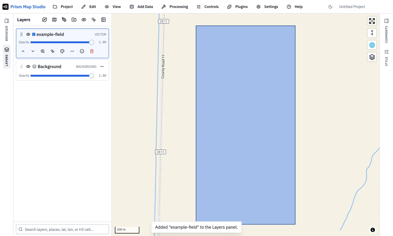
- Open Processing, then SQL Workspace. Your layer is listed under "Queryable layers" as a table, for example
example_field. - Paste this query, change the table name to yours, and press Run:
SELECT name,
       round(ST_Area_Spheroid(ST_FlipCoordinates(geom)) / 4046.8564224, 2) AS acres
FROM example_field;
ST_Area_Spheroid measures on the Earth's ellipsoid and returns square metres. ST_FlipCoordinates is there because that function expects latitude before longitude. Dividing by 4,046.8564224 turns square metres into acres. For our quarter mile by half mile example field, the answer was 80.1 acres, which matches both the survey-grid check above and a separate calculation with standard GIS tools.
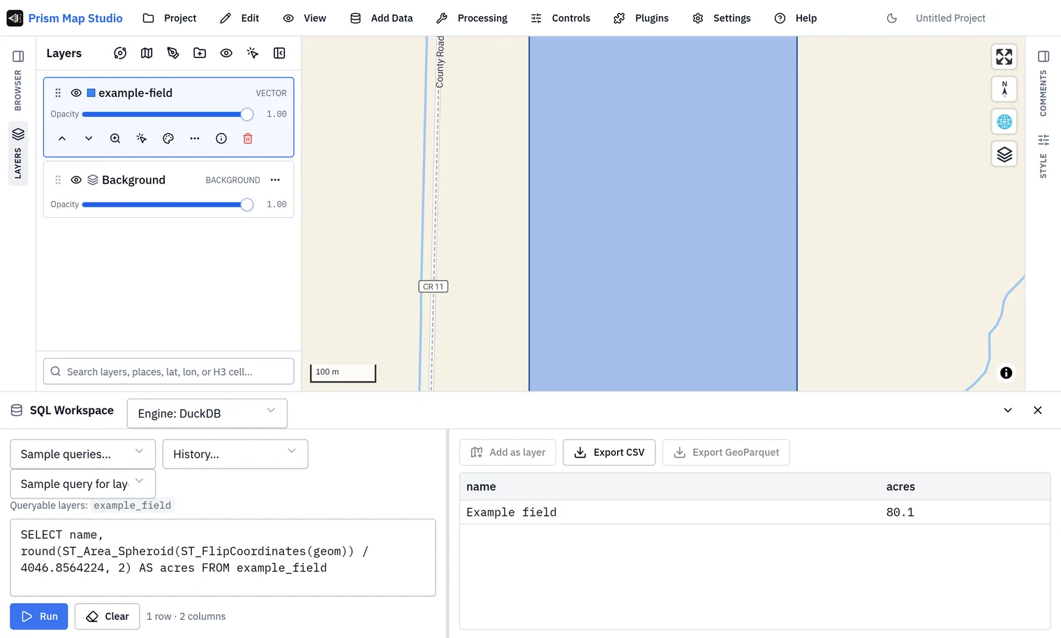
If your file holds many fields, the same query lists every one. To total them, wrap the area in sum(...) and drop the name column.
Where Prism fits
Measuring acres is one small job. The same workspace can style your fields, run more than a thousand analysis tools and ask questions of your layers in SQL. If you farm in North Dakota, Prism Microclimate puts every field in the state on one map, with a seven-day forecast and spray and frost windows; see also frost risk explained and our work in agriculture.